📢 Share This Post
Last Updated: 14 August 2026 | By: Sarthak Estates Research Team
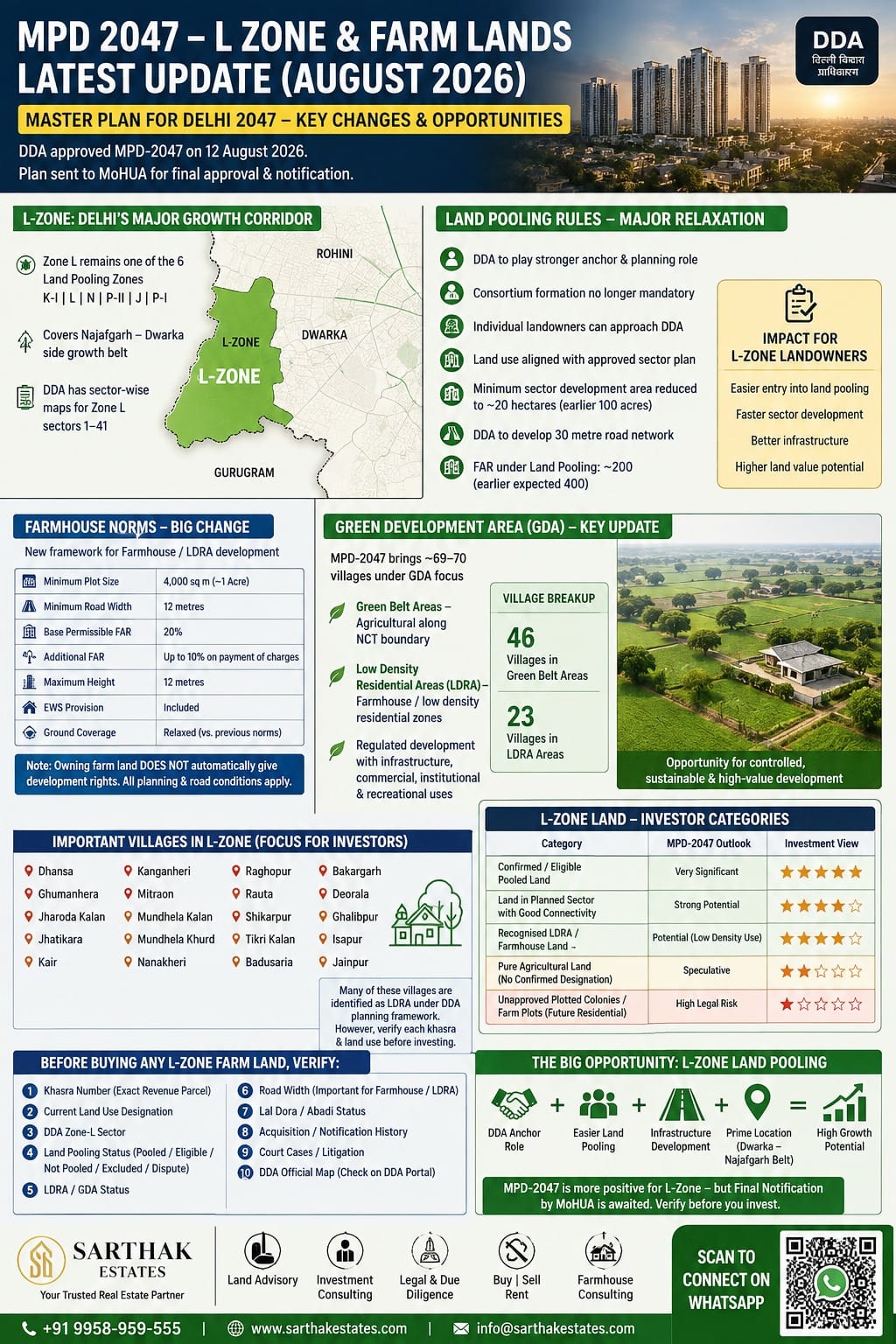
There has been a major development just this week. As of 14 August 2026, the DDA has approved the Master Plan for Delhi 2047 (MPD-2047) on 12 August 2026. However, it is not yet the final legally operative notification: the plan is being sent to the Ministry of Housing & Urban Affairs (MoHUA) for final approval and notification. Therefore, investors should distinguish between DDA-approved policy direction and currently enforceable land-use/development rights. (Hindustan Times)
MPD-2047: Biggest changes relevant to L-Zone

📞 Interested? Talk to a Property Expert
17+ years of experience · Delhi, Noida, Gurgaon, Mumbai & Dubai · Verified listings · Free consultation


1. L-Zone remains a major land-pooling zone
Zone L is specifically retained among the six zones where DDA’s Land Pooling Policy is applicable:
- K-I
- L
- N
- P-II
- J
- P-I
This is important because Zone L is one of Delhi’s largest planned urban-extension areas and includes the Najafgarh/Dwarka-side growth belt. DDA already maintains sector-wise maps for Zone L sectors 1–41 under the land-pooling framework. (The Times of India)
2. Land pooling rules are being substantially relaxed
This is arguably the most important change for L-Zone landowners.
Under the earlier framework, landowners had to overcome significant consortium/participation requirements. Under MPD-2047:
- DDA will play a much stronger anchor/planning role.
- Formation of a traditional consortium is reportedly no longer mandatory in the same manner.
- Individual landowners can approach DDA under the revised framework.
- Underlying land use can be aligned with the approved sector plan rather than requiring repeated individual land-use changes.
- The minimum sector-development threshold has been reduced to approximately 20 hectares, compared with the previous 100-acre requirement.
- DDA is expected to take responsibility for development of the required 30-metre road network. (The Indian Express)
3. FAR under Land Pooling
A major correction from some earlier market expectations:
MPD-2047 provides for FAR of around 200 under Land Pooling, rather than the FAR 400 that had been anticipated in some earlier discussions. (The Times of India)
This doesn’t mean an individual agricultural landowner can simply construct at FAR 200 today. The FAR applies within the planned development/land-pooling framework, subject to sector planning, infrastructure, development controls and final notification.
What does this mean for L-Zone farm/agricultural land?
This is where investors need to be particularly careful.
MPD-2047 does NOT mean:
“All agricultural/farm land in L-Zone has automatically become residential land.”
That interpretation would be incorrect.
The underlying land-use designation, sector eligibility, pooling status, road access, village boundary, GDA/LDRA status, environmental restrictions and eventual sector plan still matter.
DDA continues to publish the Zone-L pooled-land maps and land-pooling framework. (Delhi Development Authority)
New farmhouse norms — very significant
This is one of the most important changes for people looking at farmhouses/farm land in Delhi.
Under the MPD-2047 framework reported by DDA/major media:
| Parameter | MPD-2047 proposal |
|---|---|
| Minimum farmhouse plot | 4,000 sq m |
| Approx. area | ~1 acre |
| Minimum road width | 12 metres |
| Base permissible FAR | 20% |
| Additional FAR | Up to 10% on payment of charges |
| Maximum height | 12 metres |
| EWS provision | Included |
| Ground coverage | Relaxed compared with previous framework |
The previous framework had allowed farmhouse/LDRA development subject to different road and development-control conditions. MPD-2047 changes the framework for low-density residential/farmhouse areas. (The Times of India)
Important distinction
4,000 sq m ≈ 0.99 acre, so the commonly used description is “approximately one acre.”
But owning one acre of agricultural land does not automatically give you a legal farmhouse development right.
The plot must fall within the relevant permitted category/area and satisfy the applicable planning, road-access and other statutory conditions.
Green Development Area — another major change
The Green Development Area (GDA) concept is particularly relevant to peripheral Delhi and agricultural/farm land.
The earlier DDA GDA framework contemplated:
- Green Belt
- Low Density Residential Areas
- Agricultural/natural areas
- Green/recreational development
- Landscaping and plantation
- Food/horticulture production
- Controlled development rather than conventional urbanisation
The DDA’s published GDA policy specifically describes Green Belt as agricultural land along the NCT boundary and LDRA as identified villages with concentrations of farmhouse/low-density residential plots. (Delhi Development Authority)
The MPD-2047 direction now brings Green Development Areas across approximately 69–70 villages into much sharper focus, including commercial/institutional opportunities under regulated development. Reports indicate that around 46 villages are in green-belt areas and 23 are designated as low-density residential areas. (The Times of India)
This is potentially very important for farm-land owners.
Instead of thinking only in terms of:
Agricultural land → farmhouse
the more important MPD-2047 story is:
Agricultural/Green Belt/LDRA land → regulated Green Development Area → specified permissible uses
The actual benefit will depend heavily on the final notified regulations and the property’s exact planning designation.
Zone L villages: where I would focus
For investment analysis, I would particularly examine parcels around the Zone-L belt including villages such as:
- Dhansa
- Ghumanhera
- Jharoda Kalan
- Jhatikara
- Kair
- Kanganheri
- Mitraon
- Mundhela Kalan
- Mundhela Khurd
- Nanakheri
- Raghopur
- Rauta
- Shikarpur
- Tikri Kalan
- Badusaria
- Bakargarh
- Deorala
- Ghalibpur
- Isapur
- Jainpur
DDA’s existing planning material identifies a number of Zone-L villages as Low Density Residential Area (LDRA) villages. (DDA)
But don’t treat every parcel in these villages identically. Revenue-village location alone is insufficient; the individual khasra’s planning designation and pooling/land-use status need to be checked.
🚨 What changes for an investor?
I would divide Zone-L land into four categories:
| Category | MPD-2047 outlook | Investment view |
|---|---|---|
| Confirmed/eligible pooled land | Very significant | ⭐⭐⭐⭐⭐ |
| Land falling in planned sector with good road connectivity | Strong potential | ⭐⭐⭐⭐⭐ |
| Recognised LDRA/farmhouse land meeting norms | Potential farmhouse/low-density use | ⭐⭐⭐⭐ |
| Pure agricultural land with no confirmed development designation | Speculative | ⭐⭐ |
| Unapproved plotted colonies/farm plots sold as “future residential” | High legal risk | ⭐ |
The biggest opportunity: L-Zone land pooling
The real investment thesis isn’t simply “MPD-2047 has arrived.”
It is:
DDA + Land Pooling + smaller development threshold + DDA anchor role + infrastructure + Zone L’s location near Dwarka/Najafgarh growth corridors.
This potentially reduces one of the biggest historical problems with Zone L: fragmented land ownership and difficulty getting landowners to collectively move a sector forward.
The Indian Express reports that the revised framework is intended to make land pooling easier and that DDA would take a more direct planning/anchor role. (The Indian Express)
But there is a BIG caveat for buying farm land today
I would not recommend buying a parcel solely because the seller says:
“MPD 2047 mein residential ho jayega.”
That is not sufficient.
Before buying any L-Zone agricultural/farm parcel, verify:
1. Khasra number
Exact revenue parcel.
2. Current land-use designation
Not merely the village name.
3. DDA Zone-L sector
Determine the relevant sector number.
4. Land-pooling status
Check whether the parcel is:
- pooled
- eligible for pooling
- not pooled
- excluded
- under dispute
- encumbered
5. LDRA/GDA status
This can materially change the development potential.
6. Road width
Especially important for farmhouse/LDRA claims.
7. Lal Dora / abadi status
Don’t confuse Lal Dora/abadi rights with agricultural/farmhouse development rights.
8. Acquisition/notification history
9. Court cases/litigation
10. Actual DDA map
DDA’s official Zone-L mapping should be checked rather than relying on a broker’s coloured Google map. DDA publishes sector-wise Zone-L pooled-land maps. (Delhi Development Authority)
My 2026 investment interpretation
🟢 L-Zone land pooling = positive
The reduction in development thresholds and stronger DDA role are potentially very positive for genuine landowners.
🟢 LDRA/farmhouse land = positive but selective
The new 4,000 sq m / 12-metre-road / 20% FAR + paid additional FAR framework could improve the economics of qualifying low-density plots. (The Times of India)
🟢 GDA = potentially very significant
The formalisation of Green Development Areas could create new regulated economic/recreational/commercial opportunities in parts of peripheral Delhi. But exact permissible uses remain crucial.
🟡 Ordinary agricultural land = don’t assume conversion
MPD-2047 does not automatically convert every agricultural parcel into residential property.
🔴 Unauthorised plotting = high risk
If someone is selling “100/200/500 sq yd plots” in agricultural land with a promise of future regularisation, I would treat that as a completely different investment proposition from genuine DDA land-pooling/LDRA land.
Bottom line for L-Zone
MPD-2047 is substantially more positive for Zone L than the old status quo, particularly because land pooling is being made easier and DDA is taking a more active role.
The hierarchy I would use in 2026 is:
DDA-eligible pooled land
⬇️
Land in an eligible/strategic Zone-L sector with infrastructure access
⬇️
Recognised LDRA/GDA land with clear development controls
⬇️
Ordinary agricultural land
⬇️
Unauthorised plotted farm land
The first three require parcel-level verification, not just a village-level MPD claim.
Most important current status
DDA approval ≠ final notification. MPD-2047 is currently moving to MoHUA for final approval/notification. Until that happens, I would not price a transaction as though every proposed MPD-2047 right is already legally available. (Hindustan Times)
DDA — MPD-2041/2047 Planning Page
DDA — Zone L Pooled-Land Maps
DDA — Land Pooling Policy
If you’re evaluating actual L-Zone land for investment, the next useful step is a Zone-L 2026 investment map/list showing village → sector → land-pooling status → GDA/LDRA → road/infrastructure → current market rate → MPD-2047 impact → risk level.
Master Plan for Delhi (MPD) 2041 and Land Pooling Policy (LPP)
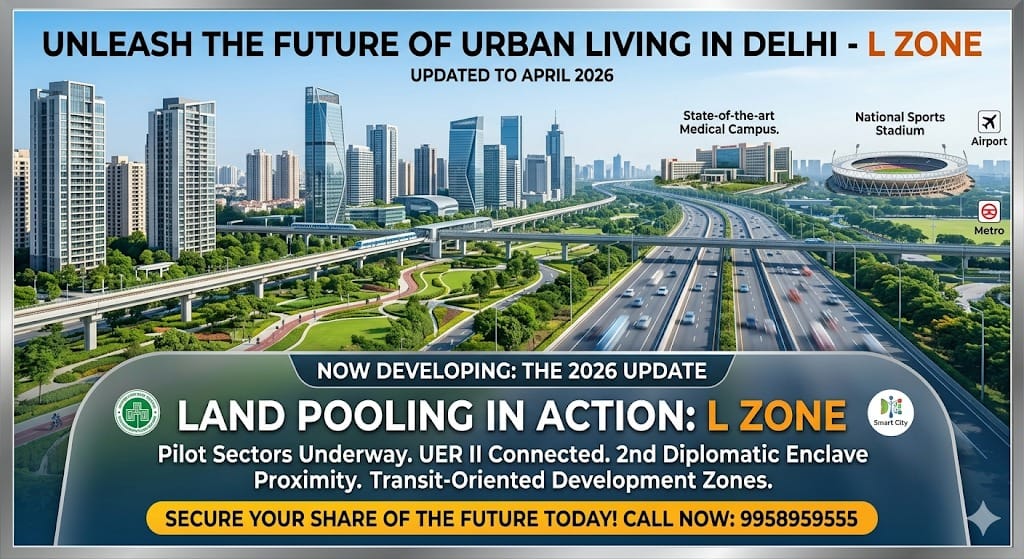
As of April 2026, the landscape for the Delhi L Zone has shifted from the “visionary plans” of 2013 to a more structured, albeit slower, implementation phase under the Land Pooling Policy (LPP) and the recently finalized Master Plan for Delhi (MPD) 2041.
📋 Table of Contents
- MPD-2047: Biggest changes relevant to L-Zone
- 1. L-Zone remains a major land-pooling zone
- 2. Land pooling rules are being substantially relaxed
- 3. FAR under Land Pooling
- MPD-2047 does NOT mean:
- Important distinction
- This is potentially very important for farm-land owners.
- 1. Khasra number
- 2. Current land-use designation
- 3. DDA Zone-L sector
- 4. Land-pooling status
- 5. LDRA/GDA status
- 6. Road width
- 7. Lal Dora / abadi status
- 8. Acquisition/notification history
- 9. Court cases/litigation
- 10. Actual DDA map
- 🟢 L-Zone land pooling = positive
- 🟢 LDRA/farmhouse land = positive but selective
- 🟢 GDA = potentially very significant
- 🟡 Ordinary agricultural land = don't assume conversion
- 🔴 Unauthorised plotting = high risk
- Bottom line for L-Zone
- Most important current status
- ## 1. Land Pooling Policy (LPP) Status: 2026 Update
- ## 2. Infrastructure & Connectivity Check
- ## 3. Comparison: Then (2013/21) vs. Now (2026)
- ## 4. Crucial Investor Note for 2026
While the core promise of L Zone remains its strategic location, several of the specific “lifestyle” claims from earlier marketing (like Disney Land) have been clarified by government updates.
## 1. Land Pooling Policy (LPP) Status: 2026 Update
The policy has moved from “paper” to “groundwork.“
Sector 8B Success: In early 2026, the DDA granted the first-ever land-use change approval for a 40.2-hectare area in Sector 8B. This is the “pilot sector” that will set the blueprint for the L Zone.
Consortium Formation: DDA has extended the deadline for landowners to form Consortiums in Sector 3 of the L Zone until late 2025/early 2026 to ensure the 70% participation threshold is met.
Mandatory Survey: As of March 2026, the DDA has launched a comprehensive GIS-based survey of all pooling zones (including L Zone) to verify land parcels and clear legal hurdles, aiming to finalize a “Priority Development Map” by late 2026.
## 2. Infrastructure & Connectivity Check
The infrastructure touted in your summary has seen varying levels of progress:
UER II (Urban Extension Road II): This is now a major reality. It serves as a semi-ring road connecting Alipur in North Delhi to NH-48, significantly improving L Zone’s access to the IGI Airport (now ~15-20 mins away).
2nd Diplomatic Enclave (Dwarka): Development in Sector 24, Dwarka is well underway. While not inside L Zone, its proximity remains a primary value driver.
Disney Land: This remains a myth for the L Zone specifically. However, the Haryana Government (as of late 2025) has proposed a world-class amusement park (often nicknamed “Disneyland-style”) in Manesar/Pachgaon, about 30-40 minutes from the L Zone.
AIIMS-2: The National Cancer Institute (AIIMS Jhajjar campus) is operational and sits within a short driving distance from the L Zone.
## 3. Comparison: Then (2013/21) vs. Now (2026)
| Feature | 2013/21 Projection | 2026 Reality |
| Primary Policy | MPD-2021 | MPD-2041 (Focuses on “Green Development Nodes”) |
| Governance | DDA as Facilitator | DDA + Consortiums (Private entities managing development) |
| Transit Focus | Metro Extension | Transit Oriented Development (TOD) – Higher FAR (up to 500) within 500m of Metro/RRTS. |
| Housing | 2.0 Million Units | Revised estimates focus on Affordable & Service Housing (65% of FAR in TOD zones). |
## 4. Crucial Investor Note for 2026
The Transit Oriented Development (TOD) Policy update in April 2026 is the biggest news for L Zone. The Centre has reduced the minimum plot size for TOD schemes to 2,000 sqm (from 1 hectare). This means smaller clusters in the L Zone near the Metro/UER corridors can now develop much higher density and mixed-use projects (commercial + residential) faster than originally planned.
Summary: The L Zone is no longer a “future dream”—it’s in the Consortium & Survey phase. While the “Disney Land” and “5-minute” claims were optimistic, the actual infrastructure (UER II and Dwarka Sector 24) has made the zone a legitimate long-term urban hub.
🏠 Ready to Buy, Sell or Rent Property?
Contact Sarthak Estates — Delhi NCR’s trusted real estate advisors since 2008. We cover Delhi, Noida, Gurgaon, Faridabad, Ghaziabad, Mumbai & Dubai.
Looking for Property in Delhi NCR?
Talk to our expert advisors – 17+ years of trusted guidance across Delhi, Noida, Gurgaon, Mumbai & Dubai.
Call: +91-9958-959-555WhatsApp UsSarthak Estates Research Team
Expert real estate advisors with 17+ years of experience in Delhi NCR, Mumbai & Dubai. We publish verified property insights, market analysis and investment guides to help buyers, sellers and investors make informed decisions.